


iNavX
Marine Navigation
iNavX: Marine Navigationの説明
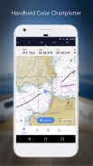
世界No.1のハンドヘルド海図プロッターであるiNavXを使えば、海洋ナビゲーションが簡単になります。海図、地図、天気、AIS などにアクセスできます。
iNavX は、すべての新しい iNavX Professional+ グローバル チャートを含む、すべてのお気に入りのチャート プロバイダーからの完全な世界チャート カバレッジを提供する唯一のアプリです!ワンタッチ アクセスで完全に有効化された iNavX を使用すると、ユーザーは次のような複数のプロバイダーから提供される海図と地図の最も幅広いセットにアクセスできます。
• iNavX Professional+ チャート
• ブルーラチチュード
• 冒険者
•彼らの天気
• 水路ガイド
• … もっと
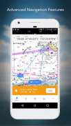
iNavX はどのようにしてハンドヘルド マリン ナビゲーションを次のレベルに引き上げますか?
• セーラー - ウェイポイントとルート管理でセーリング ルートを計画します。 GRIB 天気予報でプロアクティブな帆管理を取得し、AIS オーバーレイと搭載システムとの統合を監視します。さらに、写真にジオタグを付けることで、素晴らしいセーリングの場所を思い出すことができます。
• ボーター - 潮流、風、うねりなどの予報で、ボートの状況を最新の状態に保ちます。航海計器の統合でボート設備を管理し、素晴らしいボート ルートを保存してトラック ログと共有します。
• 釣り人 - 穴や入り江を偵察して、新しい釣りスポットを発見してください。寒冷前線を特定して最高の釣り条件を見つけ、最高の釣りスポットを無制限のマーカーで保存します。
高度な機能 - iNavX は、すべてのセーリングとボートのニーズに対応する最も機能豊富なアプリであり、手頃な価格で利用できます。
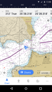
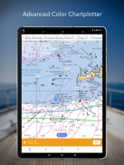
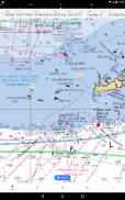
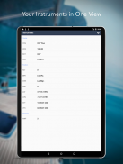
高度なチャートプロッター
• デバイスに内蔵された GPS を使用してリアルタイムで位置をプロットします
• グラフのパン、ズーム、回転 (コースアップを含む)
• アプリと組み合わせて使用する詳細チャートを印刷
高度なナビゲーション
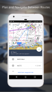
•ウェイポイントを作成し、それらの間を移動するためのルートを計画します
• トラックログでルートを記録できます
• KML (Google Earth) または GPX 形式でのデータのインポート/エクスポート
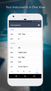
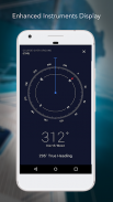
高度な計測
• TCP/IP 経由で NMEA データをサポート (Wi-Fi を使用)
• 外部 GPS、AIS レシーバー、トランスポンダーと統合
• 航海計器の接続: 深度、速度、風、エンジン、バッテリーなど。
エッセンシャル ツールキット
• GRIB 天気予報
•潮汐/海流
•アンカーアラーム
•AISの統合
• ポート/ナビ検索
iNavX TODAY をダウンロードして、公式の最新の高解像度 NOAA RNC 米国海洋ラスター チャートの無料コピーを自動的に受け取ります。
レビュー
「iNavX はオリジナルであり、今でも最高のナビゲーション アプリの 1 つです。」
– 実用セーラー
「最もフル機能のナビゲーション アプリであり、多くの人が標準として見ている」
– セイルマガジン
「海図アプリのおすすめNo.1」
- iMarineApps
iNavX は、C-MAP、Theyr Weather、Waterway Guide、AIS、Brookhouse、DigitalYacht、ShipModul、vYacht、Vesper Marine、NMEA 2000、Chetco などと互換性があります。
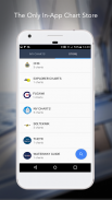
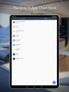
新しいチャートストア
お気に入りのチャートをすべて購入します。チャートのサブスクリプションはチャートとプロバイダーによって異なり、年間 $9.99 から $199.99 で、iTunes アカウントに請求されます。これは、現在の期間が終了する少なくとも 24 時間前にキャンセルしない限り、自動的に更新されます。自動更新は、購入後に iTunes のアカウント設定からいつでもオフにすることができます。アクティブなサブスクリプション期間中に現在のサブスクリプションをキャンセルすることはできません。
注: バックグラウンドで実行されている GPS を継続して使用すると、バッテリーの寿命が大幅に短くなる可能性があります。
より詳しい情報
ウェブサイト: http://inavx.com/
ユーザーガイド: http://inavx.com/help/
利用規約: http://inavx.com/terms
プライバシー ポリシー: http://inavx.com/privacy
iNavX: Marine Navigation- APK情報
APKバージョン: 1.6.6パッケージ: com.gpsnavx.iNavXiNavX: Marine Navigationの最新バージョン
他のバージョン


同じカテゴリのアプリ

その他のおすすめ...


